Spatial analysis is our secret weapon, the geospatial equivalent of Kryptonian X-ray vision. GIS mapping layers all kinds of data about a specific spot on the planet onto a map. Some of the data is high-tech stuff, like satellite imagery and 3D LiDAR land models made by lasers or drones; some info comes from good old-fashioned boots-on-the-ground work, such as GPS field surveys and federal, state, and municipal databases. This rich combination of information superimposed onto geography shows us exactly how a given piece of terrain works and, even more importantly, why. For trail planners and builders, there’s no greater tool.
Every plan we create begins with GIS. Using as much information as we can get—CAD drawings of development areas, topographical maps, FEMA flood planes, slope measurements, tree cover data, utilities maps—we create our base maps for initial study and preliminary planning on the desktop before we even set foot into the field. This makes our site visits smarter and more productive, giving us a chance to identify in advance zones of difficult terrain or other constraints and zero in on areas for study so we can minimize the guesswork and focus on prime trail and recreation land.
Our deep knowledge and understanding of GIS data enables us to scout opportunity and pinpoint risk, helping us deliver safe, intelligent designs faster and easier. And smart, sleek designs mean fewer delays and unexpected issues—before the first shovel hits dirt, we know we’re working with the land, not against it, finding natural flow and maximizing potential with no guesswork.
If you’ve got hopes or plans for a piece of land, this is a job for…Avid’s GIS department! We can help you identify and interpret prospects and constraints through spatially accurate, scientific analysis, leaving you with peace of mind and the geo-referenced, data-backed files to go with it. No cape required.
Trail planning steps
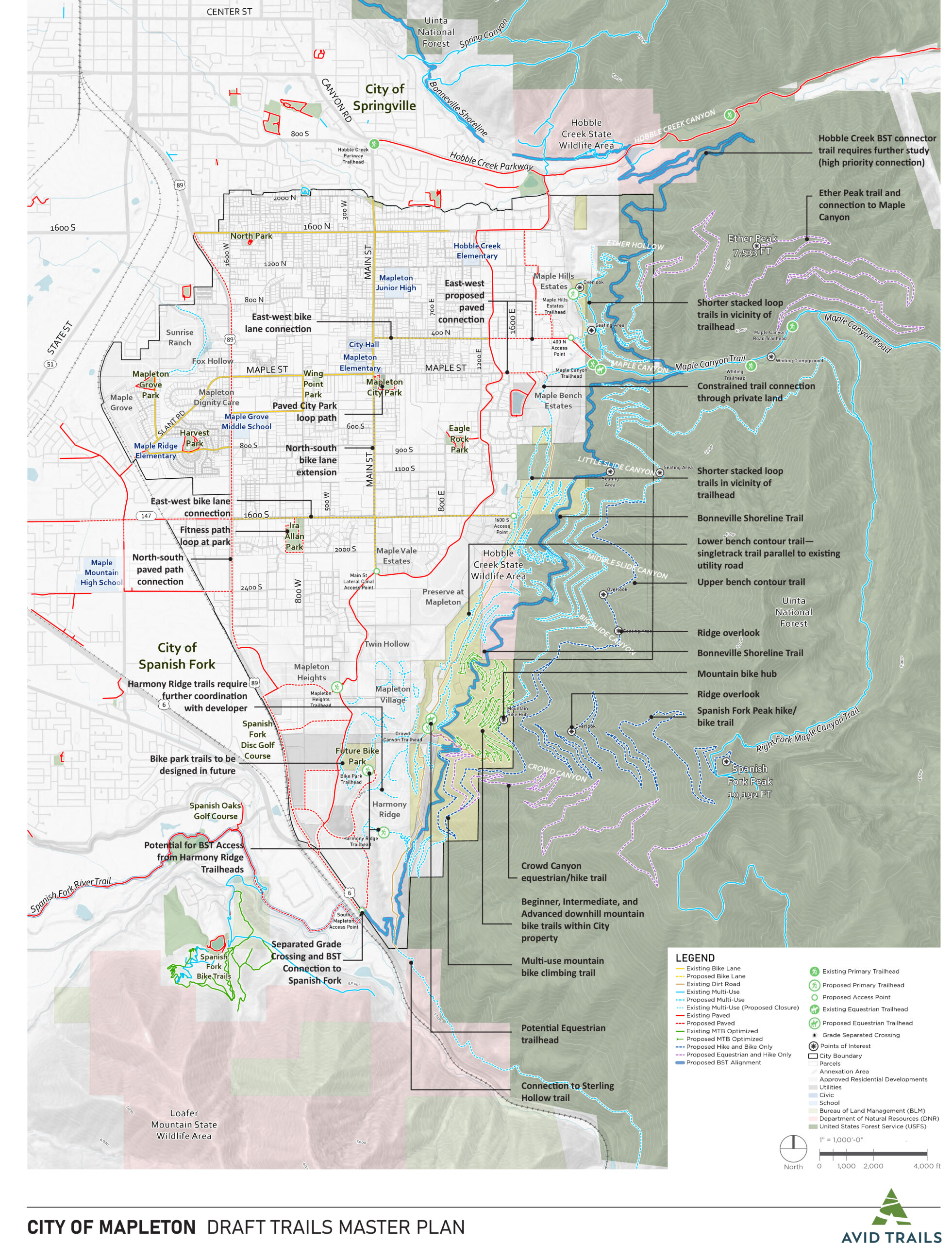
Trails Master Planning
Complete trails planning for municipalities and land developers
Pump Tracks & Bike Parks
We design and build awesome flow trails, pump tracks, skills loops, and jump lines.
Trail Signage & Wayfinding
Trail maps, directionals, trailhead kiosks and interpretive displays are all important parts of wayfinding.